
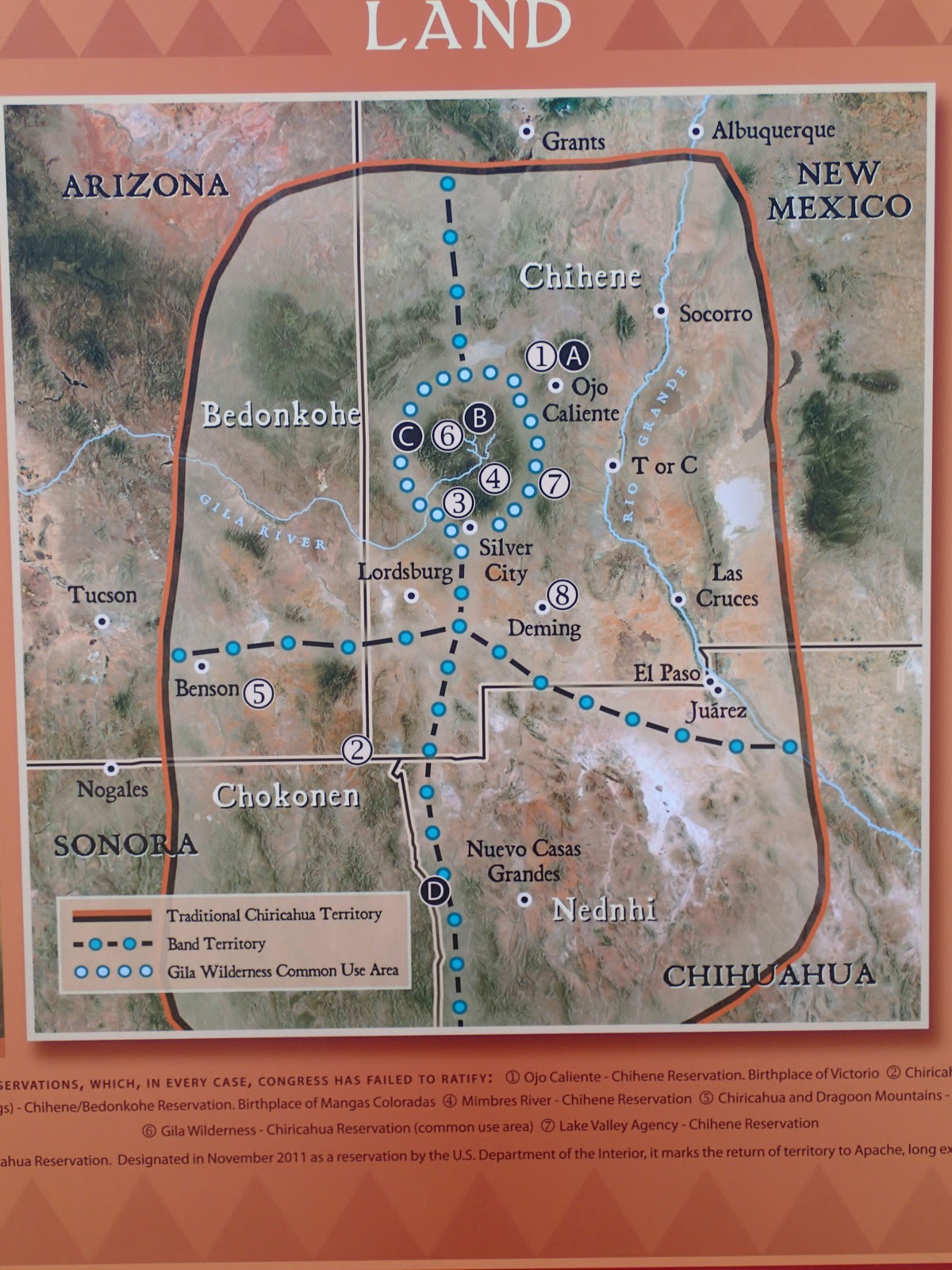
This is the region of old Apache lands, a region the US Calvary ambitiously chased Geronimo into. Knowing this land better than any, finally made his surrender in the Peloncillo Mtns on the Nm/Az border. These Mtns hovered on the the horizon to the west.
 The CDT is two mountain ranges over easterly in the Big Hatchets separated by the Animas Mtns. The actual geological divide runs through the Animas but is off limits. For the sake of making a southern terminus close to the divide this fit the bill quite nice. It had all the features any adventorous soul would want.
 |
| under the border and a push up for both countries |

The ecology is quite unique in these parts of the southwest. These mountains harbor more diversity than most would acknowledge. Plants grow vibrantly without much water here. The Hatchets are known for supporting a herd of desert bighorn sheep as well. These mountains in the southern latitude boast what would be referred to as "the sky islands region" where the land has drastically risen from the desert floor and appears exactly like an island, nurturing a select unique group of species that call it home. They harbor life in a transition zone between the even lower latitudes of Mexico's Sierra Madre and America's northern latitudes of sub/alpine life zones.
Even more specifically, bridging the greater Gila Wilderness, which holds the Mogollon Rim of the most southern edge of the Colorado Plateau.The plateau is a vast space below the Rocky Mtns. Where the land falls away and the water drains south westerly. Ultimately, the greater gila would be called the "Sierra madre occidental".
 |
| Big Hatchets |
 |
| ocitillo |
After all that, I'm not sure if the Big Hatchet's actually fit the criteria to be a true sky island. Falling short of the proper elevation. But they surely appear so and the sister range, Animas Mtns, a valley over to the west truly is.
The trail itself was a mix of very little single track, old 2 track BLM roads, and line of sight cross country. The route was pretty well flagged with sign posts leading you to the next. For the most part there really wasn't a trail and seemed as if all the hikers are gradually etching out a path with real time usage. A real "feet on" approach for trail construction. The route stayed low skirting the mountains, walking through some canyon washes, without having to make any ascents.
 |
| parry's agave |


Water was a concern but we found it more available than we would have expected. Between the 5 BLM cache box's and an array of ranchers cow tanks it wasn't so bad. Maybe 15 miles at the most between a source.


FULL Album
No comments:
Post a Comment