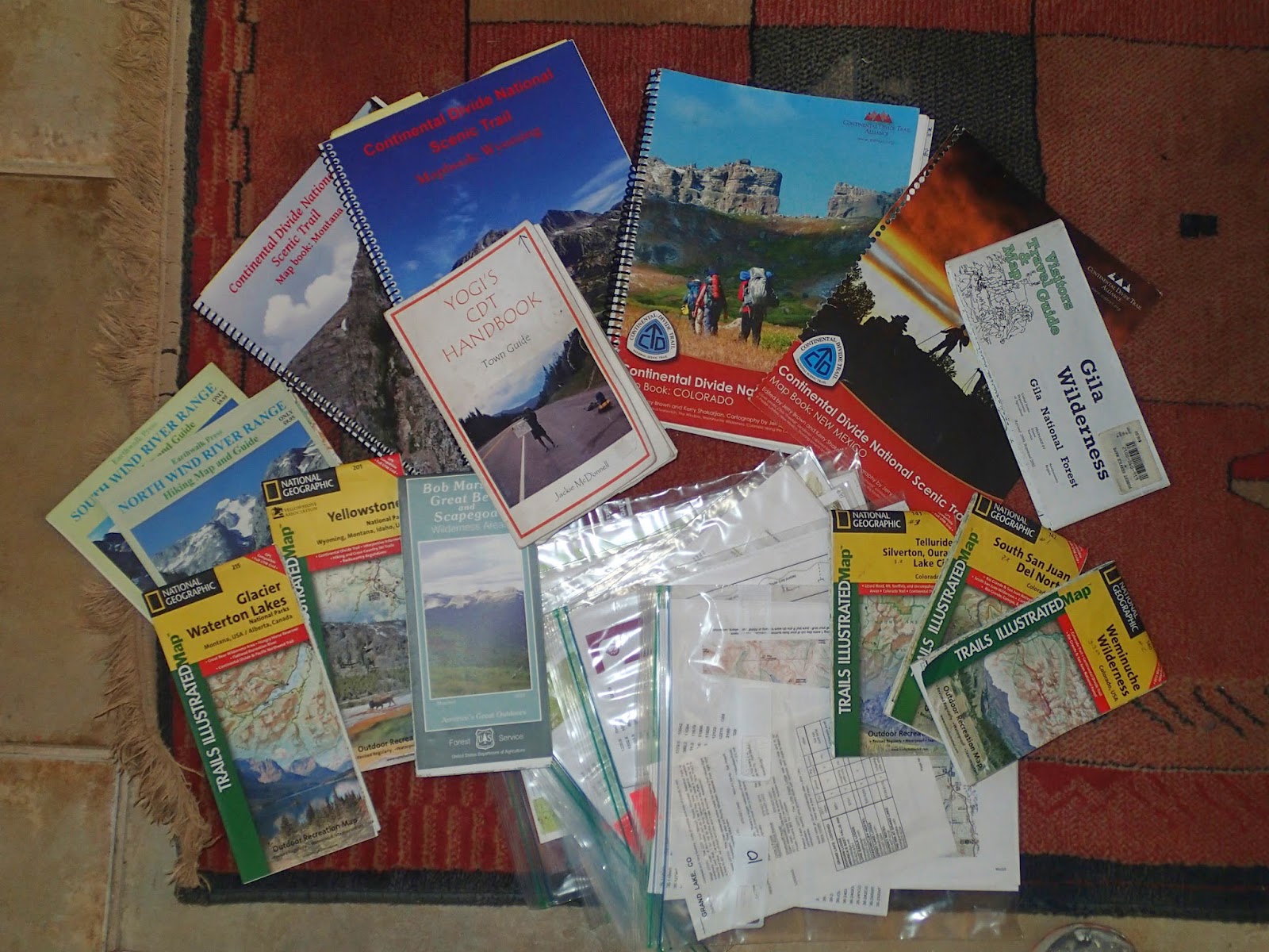
Pages

Monday, July 21, 2014

Grand Lake - Steam Boat Springs

So here I sit in the library in Steam Boat Springs. Trying to catch up with photos and making an attempt to actually make a live current post. It has been extremely hard to keep up as we move up the trail. And unfortunately I can't get photos uploaded to these computers. It won't recognize my picasa web album sign in.

We are at our last town in Colorado! It looks like we have 50 sum miles to the Wyoming state line.
Colorado has been amazing. A real beast however to hike through. Huge climbs day after day for almost 7 weeks. A bit exhausting.

 We are looking forward to leaving the mountains for awhile as we approach the Great Basin of Wyoming.   A bit of a break from the strenuous high rockies of Colorado. This is a section were we can make bigger miles like 35-40 a day and make some headway with time hopefully. Still a real challenge in other respects though. Extreme heat with no shade coverage, potential high winds and lack of water sources. And miles of flat endless dirt roads. A real treat like a hidden gem!

We are really starting to feel the time crunch for finishing the trail at the Canadian boarder by late September.
It becomes a bit daunting at this point when we haven't quite reached the half way point either. July 27 will be 3 months already and we have only 2 months to finish.

VD

Frisco - Grand Lake

Grays Peak Route- highest on the divide 14,202 with Argentine Spine
130 Mi stretch
Front Range
Vasquez Pk wilderness
Berthoud Pass
James Pk wilderness
Indian Pks wilderness
Rocky Mtn National Prk


Twin Lakes - Frisco

Salida - Twin Lakes

https://picasaweb.google.com/117216991580298080803/SalidaToTwinLakes?authkey=Gv1sRgCL_t9pTUz9ej8AE


Lake City - Salida

https://plus.google.com/photos/117216991580298080803/albums/6030525249344351009

Friday, June 13, 2014

Chama NM - Pagosa Springs CO

https://picasaweb.google.com/117216991580298080803/ChamaPagosaSprings?authkey=Gv1sRgCOyDrPSiuMSaIw

Ghost Ranch- Chama

Full Album

Cuba - Ghost Ranch

Full Album

Grants- Cuba

Full Album
https://picasaweb.google.com/117216991580298080803/GrantsCuba111Mi?authkey=Gv1sRgCNWrz-vazdbmBw

Pie Town - Grants

FULL ALBUM
https://picasaweb.google.com/117216991580298080803/PieGrants?authkey=Gv1sRgCKGQjdbHyeiGSA


We stayed at Nita's Toaster House in pie town which is her old personal house now dedicated to strictly being a hiker/biker hostel for CDTer's. This has to be one of the most unique places to stay along the CDT. We were greeted with huge, welcoming, warm hospitality. Nita loves us hikers and wants to talk about everything and anything! There's not much going on in pie twn except for world class pie at a few cafes. And not even a grocery. We sent our food box to Nitas. The relaxed nature of the hostel proved to be the best thing to come along up the CDT so far. She was very gracious and drove a car load of us over to the next town Datil for diner, having the largest steak I have ever had in front of me.


Leaving Pie was a bit daunting knowing we had a long gravel road walk in front of us which was really a continuation of the long road into Pie. No end in sight. Just road and vastness.


Silver City - Pie Town

CHECK OUT FULL PHOTO ALBUM   

https://picasaweb.google.com/117216991580298080803/SilverCityPieTwn?authkey=Gv1sRgCPyh4p2urK2ewgE


This section covers a large 165 mile section that includes the 45 miles from silver city up to Doc Campells general store resupply point wthin the Gila Widerness. In addition to the undertaking of hiking up through the heart of the gila middle fork river some 39 miles. This is a highly anticipated section because of the majestic huge canyon walls. Not to mention an abundance of fresh running water in the desert southwest, that requires fording the river some 85 times. This year was even more anticpated because the class of 2014 where the first hikers to experience the canyon after last fall's devistating flash flood that ravaged the canyon floor, including the trail itself. Accumalating too the most massive, tangled
debris pile's of trees one could possibily ever experience. Resulting in a duanting obstacle course over and around all of this. Not to mention now crossing the river some 200? times, from the count of other hikers keeping track. Also sludging through deep, thick sand now exposed on the shores and floor bottom of the canyon. A very challenging and exhaustive mixed terrain experience.


 However within all of this, we still had a fabulous experience through the Gila. This is a jawdropping, enchanted place.There is alot of power here. One can feel the vibrancy of life thriving here in these canyons. An abundance of plant life growing in these riparian corridors. Sustaining an active wildlife population that frequent these rivers. Including the fresh mountaion lion and bear prints we came across. Loads of bear scat, deer and elk coming down for a drink.
bear

lion


One of the highlights for ourselves was also finding an array of wild edibles and medicinal plants we were familar with. Picking sample tastes as we walked up the river. The best was making a salad out of watercress, mustard greens and dandelion leafs. A delightfully bitter array. Something my body was craving, veggies full of vitamins and minerals. A source of extremely clean nutrition.


Other plants included canyon grape leafs, lambs quarter, cattail root, wild geranium, cordanopsis, lemon berry/buffalo berry, horestail seed heads and fern fiddle heads.
horsetail

mustard
fiddle heads


wild grape


Also within this stretch includes the gorgeously wild Jordan hotspring along the gila middle fork.


And also unimproved native ruins up in the canyon walls.


Beyond the relief of clearing the river and the northern boundary of the Gila wilderness, included three more days to actually reach Pie Town. Climbing through the Tularosa and Mangas Mtns with a mixed variety of single track trail and mostly forest 4WD  roads. And now back to finding water was a legitamate concern.
Manageable but with a variance of 10-15 miles between sources.


road to Pie town


 Finally arriving at our in town hiker hostel
Nitas Toaster house


Crazy Cook /Mexico Border-Lordsburg

The journey down to the NM border lands of the forgotten bootheel gave a great sense of remoteness. A place where no one goes in any given common day. A rugged vast space. Craggily large uplifted  mountains, signs of ancient volcanism, and low laying sandy desert floors.

This is the region of old Apache lands, a region the US Calvary ambitiously chased Geronimo into. Knowing this land better than any, finally made his surrender in the Peloncillo Mtns on the Nm/Az border. These Mtns hovered on the the horizon to the west.


The CDT is two mountain ranges over easterly in the Big Hatchets separated by the Animas Mtns. The actual geological divide runs through the Animas but is off limits. For the sake of making a southern terminus close to the divide this fit the bill quite nice. It had all the features any adventorous soul would want.
under the border and a push up for both countries


The ecology is quite unique in these parts of the southwest. These mountains harbor more diversity than most would acknowledge. Plants grow vibrantly without much water here. The Hatchets are known for supporting a herd of desert bighorn sheep as well. These mountains in the southern latitude boast what would be referred to as "the sky islands region" where the land has drastically risen from the desert floor and appears exactly like an island, nurturing a select unique group of species that call it home. They harbor life in a transition zone between the even lower latitudes of Mexico's Sierra Madre and America's northern latitudes of sub/alpine life zones.
Even more specifically, bridging the greater Gila Wilderness, which holds the Mogollon Rim of the most southern edge of the Colorado Plateau.The plateau is a vast space below the Rocky Mtns. Where the land falls away and the water drains south westerly. Ultimately, the greater gila would be called the "Sierra madre occidental".

Big Hatchets
ocitillo


After all that, I'm not sure if the Big Hatchet's actually fit the criteria to be a true sky island. Falling short of the proper elevation. But they surely appear so and the sister range, Animas Mtns, a valley over to the west truly is.

The trail itself was a mix of very little single track, old 2 track BLM roads, and line of sight cross country. The route was pretty well flagged with sign posts leading you to the next. For the most part there really wasn't a trail and seemed as if all the hikers are gradually etching out a path with real time usage. A real "feet on" approach for trail construction. The route stayed low skirting the mountains, walking through some canyon washes, without having to make any ascents.
parry's agave


Water was a concern but we found it more available than we would have expected. Between the 5 BLM cache box's and an array of ranchers cow tanks it wasn't so bad. Maybe 15 miles at the most between a source.


FULL  Album

Friday, April 25, 2014

DIVIDE THE WATER - CDT

the great western mere lady, can you see her?


DIVIDE THE WATER


Drain the Waters
Decide Fate
Magnetic Polarities
Pull Truth
Decide Direction

Choice Made

Gravity Dictates
Threshhold Wanes
Light Illumines
Dawn by Dusk
Moon Waxes
Tide by Night

Current Swift 
Current Calm

Decide Fate
Truth Dictates

Future Made

Carried Wayward
OnWard Way
Thresholds Bind
Spawn and Thrive

Magnetic Polarities
Pull Truth
Harmonize
Rearrange

Current Swift 
Current Calm

Divide the Waters


VD<>38
eternity infinity


An original poem clearly inspired by the CONTINENTAL DIVIDE


We are Sarah "Majik" Fontaine and Matt "Vulture Death" Lesniewicz (MVD)
Majik Vulture Death is totemic in nature, bridging mystery and magic.


As the motto goes for the CDT embrace the brutality.
And I say .......


EMBRACE


THE


DIRT


THE


PAIN


                 THE GLORY


THE BUEATY


THE MAGIC


HIKER TO TRAIL


TH- CRAZY COOK 4/27/14


That's it, we're leaving Santa Fe today 4-25 to begin the journey down to the US/Mexico border. Stopping in Lordsburg to pick a shuttle up Sunday morning.


Sunday, April 13, 2014

CDT Planning

MAP STUFF

Data overload

Like any thru hiker knows there's a ton of planning involved. Especially with the CDT. Making sense of all the route choices. What's official and what's the ALT. Some of those will dictate your town choices and some will be less of a thing, just making a decision within the particular section.

Since there's two of us we are both going to carry a different map set. I will carry the Bear Creek Map books along with a GPS, compass and Majik will carry the Ley maps, Beacon Data spread and Yogis town guide. Having collected all of the above it is just to hard to make a decision what to leave sitting at home. I know it might seem like over kill and extra weight to add. But in this way it really feels like we got the trail covered. If we get split up we each have maps. Hopefully not though because this is a trail we should be sticking together more so. Now we just need to see it on the ground!

I am interested in it as a experiment of trial and error, to see which set of maps we favor.

As we go, if all the maps seem redundant, than I would opt out for dumping the Bear Creek maps.
I would favor the Leys because they do show all of the variables lending to options and choice. If one were to just stick with the official maps you might be shit out of luck on a few occasions. Where logically and directionally it just doesn't make so much sense. And you will find yourself walking that 3100 miles. Better plan on starting early for that!

I would also say that now having Leys maps printed professionally by Yogis printing press makes a world of a difference in the quality and rivals the Bear creek maps. Leys are simply more diverse.
This is a huge leap forward printing Leys professionally! Would totally recommend paying the $25 to yogi and donating to Ley and calling it done. Instead of buying all the ink $$ and nursing the printer.

Out of all the info we still won't be using any guide book like Wolf's. Mostly because we are going Northbound. And they are written south bound. I do have the Vol 1 Northern Montana that is north oriented. So I might throw that in for the novelty aspect. Undecided.
I have all the old CDTA books as well. They actually have been useful in studying the general spread of the CDT. Watching what has changed and I think has remained the same. There's a few sections of those I thought about throwing in also. Probably not necessary.
Oh yeah, then there's the Delormes and a few Topos.


ROUTES WE ARE TAKING W/ALTS

NM 
gila middle frk
Mangas mtns to pietown (old common way)
official- Chain of Craters (might as well be an alt)
Mt Taylor summit
might walk official past Chama River mesa above echo amp -hitch to GHST RNCH
hike out GHST   

CO
Going for San Juans
Greys Torrey
might go for Rocky mtn Nat'l

WY
Cirque of Towers

ID 
Henry Lakes

MT
Anaconda
Waterton


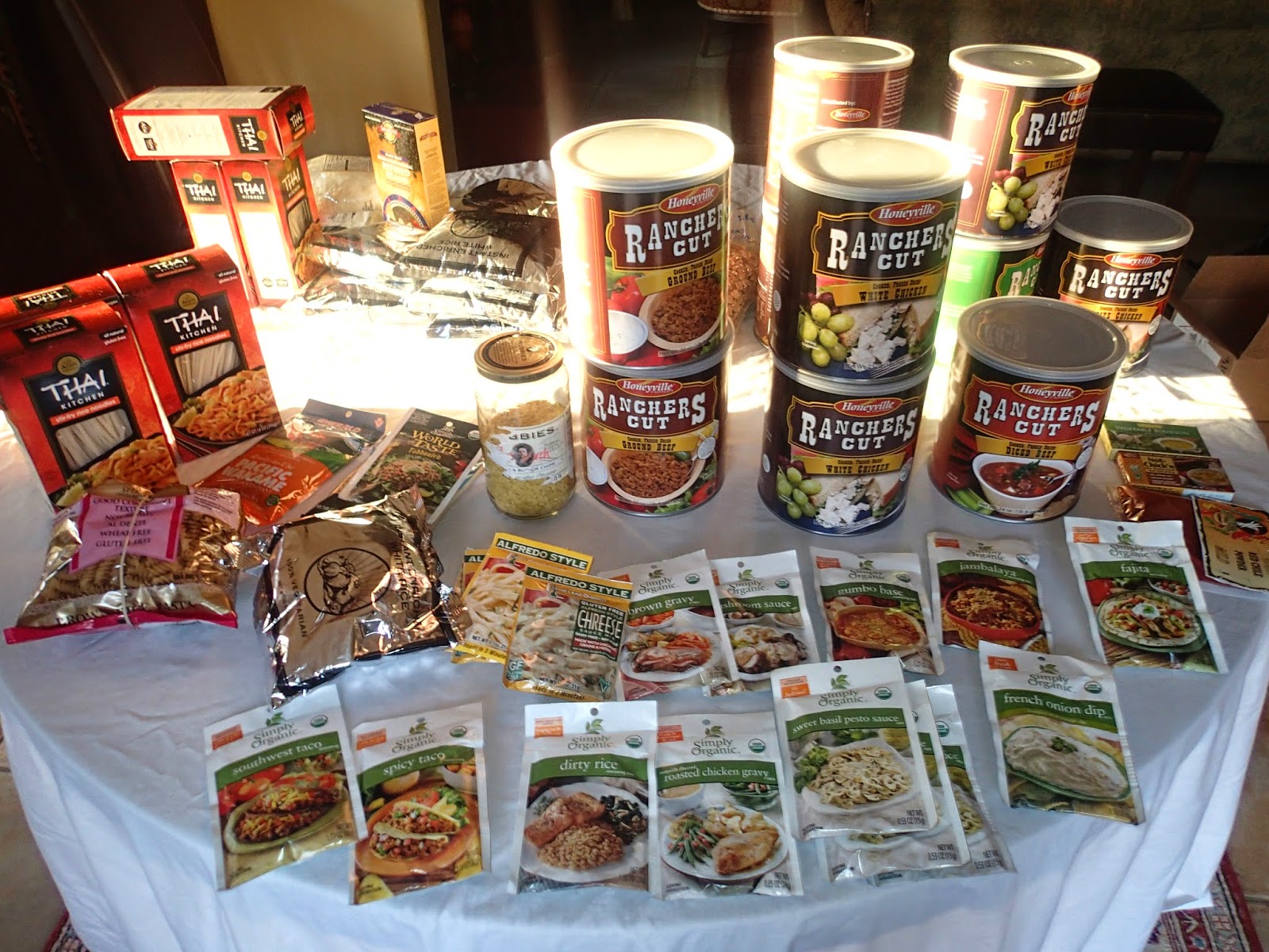
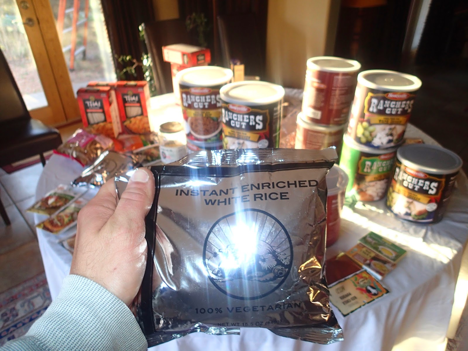
honeyville meats and veggies


FOOD STUFF

Our planning has been even more challenging because we are sending a lot of boxes from home.
Mostly because of Majiks dietary needs. Food allergies and such. If she's sending one, I figured I might as well. Actually in the long run I think this is better. Just way more of a task.
This way we can be real selective of what we are eating. Pack the good stuff. Healthy, nutritionally  satisfying meals and snacks. We eat really healthy off trail so this would not be the point to change.
Also in the long run I think we are eating for cheaper than buying in town. And our food weight should be lighter as well.

-HOW ARE YOU DOING THIS?
We put together some 85 meals of freeze dried meats and vegetables. Added seasoning packs like Simply Organics- sauces along with a choice of a base carbohydrate- mostly freeze dried rice, mashers or noodle.
Next step is the vacuum sealer for long term preservation.
We bought bulk cans of the meat and vegetables from Honeyville Farms.

-COOKING
should be a breeze- presoak-add boiling water or just soak much longer and eat it room temp UMH........
Talking with Dirtmonger on his Vagabond Loop, turned us on to this concept. He goes completely cook less and just soaks his meals in a little tupper ware container.
I'm not totally ready to go cook less but should prove to be viable if the fuel runs low on few long stretches. Which we are planning on doing, skipping a few of those obnoxious resupply points. Would rather just stay out and make the longer haul.
Using alcohol stoves this time around.


freeze dried rice by the 5gl bucket!

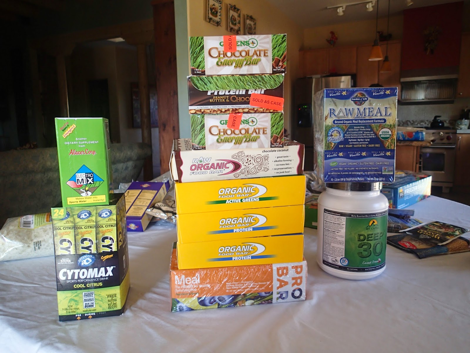
love the organic food bars, pricy though$$
protein powder- electrolytes


-WILL YOU GET TIRED OF THE SAME OL SAME OL ?
Well hopefully not. Hopefully I was creative enough. And there's enough variety within one given box.
And yes we left some towns open for buying in town. Providing even more variety.

We will be using 9 towns for Full Resupply and 18 Mail Drops = 27 stops.


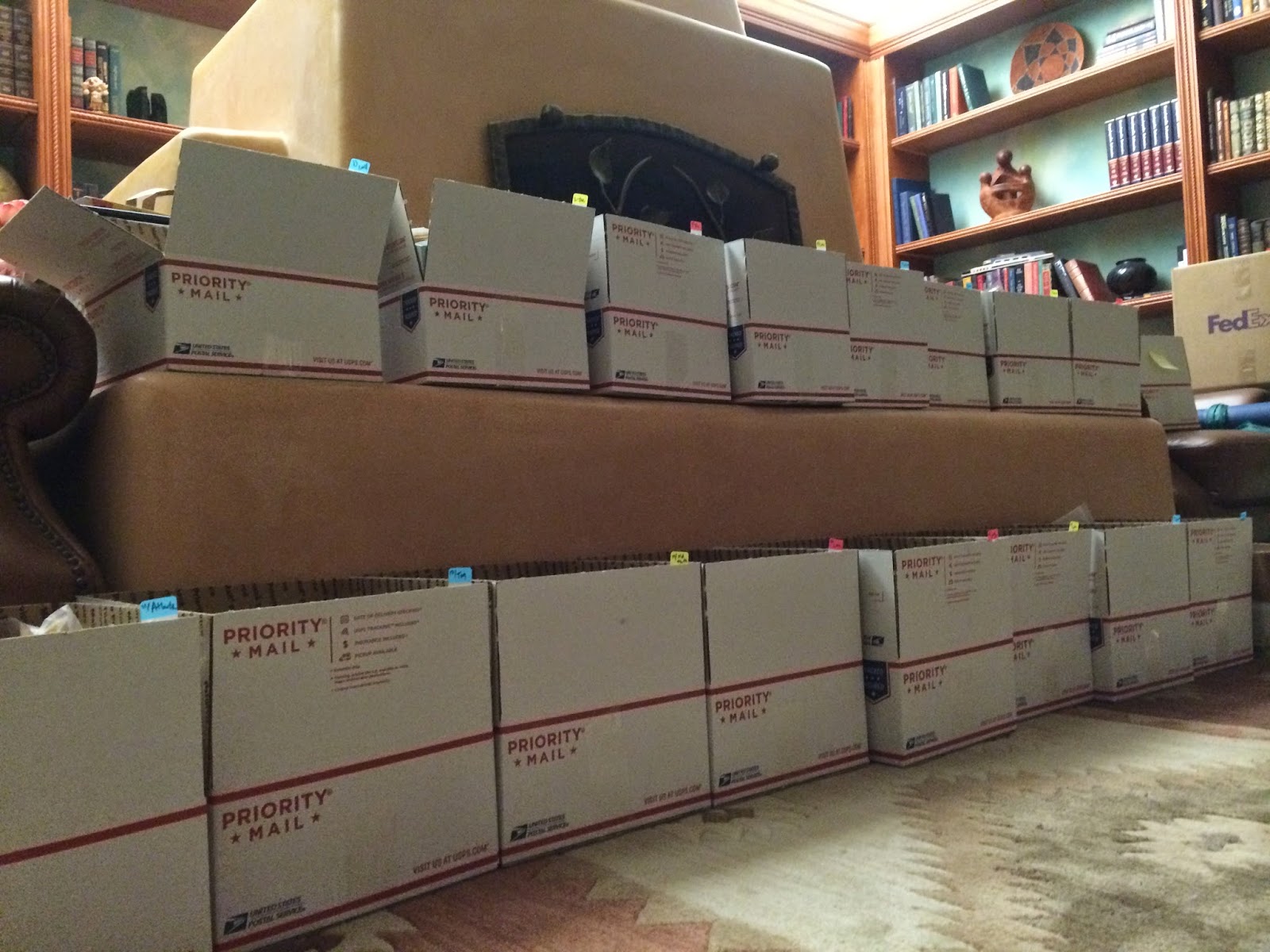
:-84 MEALS: HOW MANY RESUPPLIES IS THAT?
From my calculations.......hmh.........18 towns and most will be X 2 people =36
Shoes 4 each x 2 =8
Boxes roughly 44
Even viable resupply towns like Pagosa Springs we are sending in. Our strategy is to have the good stuff packed right for such a challenging section.
OTHER STRATEGY would be to supplement snacks in towns if we feel the boxes are inadequately packed. Mostly concerned with providing good meals.

-WON'T THAT JUST COST MORE W/SHIPPING- ARE YOU REALLY SAVING?
The best I can say is use Regional Flat Rate boxes. It's less than half the price compared to Priority mail.
Also we live in NM so the closer your region the better.
Example: Lordsburg 7.00 flat/priority 17.00

Also having already invested in a lot of the food expenses should feel like savings on the trail (psychologically speaking)